Mt. St. Helens: Difference between revisions
(create St. Helens page) |
m (add image) |
||
| (2 intermediate revisions by one other user not shown) | |||
| Line 1: | Line 1: | ||
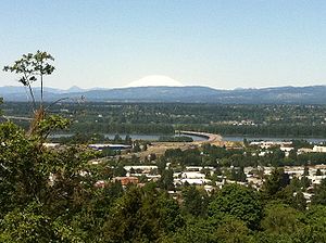
'''Mt. St. Helens''' is a volcanic mountain about 50 miles north of Portland. It's notable for blowing its top (side, actually) on May 18, 1980. Helens is still active, including a 2004-2006 period of growth and small eruptions. | [[File:Mount St Helens from Rocky Butte.jpg|right|300px|thumb|St. Helens from Rocky Butte]] | ||
'''Mt. St. Helens''' is a volcanic mountain about 50 miles north of Portland. It's notable for blowing its top (side, actually) on May 18, 1980. Helens is still active, including a 2004-2006 period of growth and small eruptions. On clear days, Helens is often visible from Portland. | |||
==Visiting== | ==Visiting== | ||
There are two ways to drive to see Helens. The most common is the [http://vulcan.wr.usgs.gov/Volcanoes/MSH/NatMonument/PointsInterest/johnston_ridge.html Johnston Ridge Observatory] on Highway 504. Drive north to Castle Rock, Washington, then east on [http://en.wikipedia.org/wiki/Washington_State_Route_504 Highway 504] until it ends. | There are two ways to drive to see Helens. The most common is the [http://vulcan.wr.usgs.gov/Volcanoes/MSH/NatMonument/PointsInterest/johnston_ridge.html Johnston Ridge Observatory] on Highway 504. Drive north to Castle Rock, Washington, then east on [http://en.wikipedia.org/wiki/Washington_State_Route_504 Highway 504] until it ends. | ||
The other way is to go to the east side on Forest Road 25. This route goes north from Sprint Lake to Randle, Washington. The road is very bumpy and narrow. It is not advised for large vehicles and RVs. The side route of Forest Road 99 gives visitors a great view of the crater and of Spirit Lake. | The other way is to go to the east side on Forest Road 25. This route goes north from Sprint Lake to Randle, Washington. The road is very bumpy and narrow. It is not advised for large vehicles and RVs. The side route of Forest Road 99 gives visitors a great view of the crater and of Spirit Lake. | ||
Both of these roads are closed in the winter and typically don't open until late June. Check the [http://www.fs.fed.us/gpnf/recreation/current-conditions/roads.shtml current road conditions] for the status of SR504, FS25, and FS99 before going. | Both of these roads are closed in the winter and typically don't open until late June. Check the [http://www.fs.fed.us/gpnf/recreation/current-conditions/roads.shtml current road conditions] for the status of SR504, FS25, and FS99 before going. | ||
[[Category:Mountains]] | |||
Latest revision as of 14:21, 29 August 2011

Mt. St. Helens is a volcanic mountain about 50 miles north of Portland. It's notable for blowing its top (side, actually) on May 18, 1980. Helens is still active, including a 2004-2006 period of growth and small eruptions. On clear days, Helens is often visible from Portland.
Visiting
There are two ways to drive to see Helens. The most common is the Johnston Ridge Observatory on Highway 504. Drive north to Castle Rock, Washington, then east on Highway 504 until it ends.
The other way is to go to the east side on Forest Road 25. This route goes north from Sprint Lake to Randle, Washington. The road is very bumpy and narrow. It is not advised for large vehicles and RVs. The side route of Forest Road 99 gives visitors a great view of the crater and of Spirit Lake.
Both of these roads are closed in the winter and typically don't open until late June. Check the current road conditions for the status of SR504, FS25, and FS99 before going.