Cascadia subduction zone: Difference between revisions
WikiMaster (talk | contribs) m (Undo vandalism.) |
WikiMaster (talk | contribs) m (Transclude intro.) |
||
| (One intermediate revision by one other user not shown) | |||
| Line 1: | Line 1: | ||
<section begin=Cascadia subduction zone intro /> <!-- Begins transcluded content. Please do not remove; will disrupt content transclusions to other pages. More info: http://en.wikipedia.org/wiki/Transclusion --> | |||
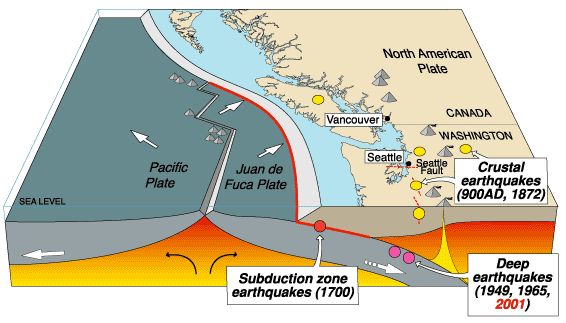
[[wikipedia:Cascadia subduction zone|The Cascadia Subduction Zone]] stretches from northern Vancouver Island to northern California. It is a very long sloping fault that separates the [[wikipedia:Juan de Fuca Plate|Juan de Fuca plate]] and [[wikipedia:North American Plate|North America plates]]. | |||
A Cascadia Subduction Zone Quake will generate two Tsunami waves, one propagating towards the coast, and the other towards the deep ocean and Hawaii.<ref>[http://www.stccmop.org/tsunami/ Center for Coastal And Land-Margin Research] - Science for Society: Impact of tsunamis on Oregon coastal communities</ref><ref>[http://www.tsunami.org/ Pacific Tsunami Museum]</ref> | |||
It will take only minutes to reach the coasts of Oregon, Washington, southern British Columbia, and northern California with wave heights reaching close to 12m (~36ft) in some scenarios. | It will take only minutes to reach the coasts of Oregon, Washington, southern British Columbia, and northern California with wave heights reaching close to 12m (~36ft) in some scenarios. | ||
<section end=Cascadia subduction zone intro /> <!-- Ends transcluded content. Please do not remove; will disrupt content transclusions to other pages. More info: http://en.wikipedia.org/wiki/Transclusion --> | |||
[[File:Cascadia.subductionzone.jpg|center|Cascadia Subduction Zone]] | [[File:Cascadia.subductionzone.jpg|center|Cascadia Subduction Zone]] | ||
| Line 184: | Line 186: | ||
* [http://vearthquake.calstatela.edu/edesktop/VirtApps/VirtualEarthQuake/VQuakeExecute.html Virtual Earth Quake] | * [http://vearthquake.calstatela.edu/edesktop/VirtApps/VirtualEarthQuake/VQuakeExecute.html Virtual Earth Quake] | ||
* [http://www.isc.ac.uk/ International Seismological Centre] | * [http://www.isc.ac.uk/ International Seismological Centre] | ||
* [http://earthquake.usgs.gov/earthquakes/recenteqsww/ USGS Global Quake Map] | * [http://earthquake.usgs.gov/earthquakes/recenteqsww/ USGS Global Quake Map] | ||
* [http://wiki.openstreetmap.org/wiki/2011_Sendai_earthquake_and_tsunami OpenStreetMap: Sendai Quake] | * [http://wiki.openstreetmap.org/wiki/2011_Sendai_earthquake_and_tsunami OpenStreetMap: Sendai Quake] | ||
| Line 191: | Line 192: | ||
* [http://www.tsunami.noaa.gov/prepare.html Tsunami Mitigation] | * [http://www.tsunami.noaa.gov/prepare.html Tsunami Mitigation] | ||
* [http://news.google.com/news/section?pz=1&cf=all&ned=us&hl=en&q=topic:earthquake&ict=clu_top/ Google Quake News] | * [http://news.google.com/news/section?pz=1&cf=all&ned=us&hl=en&q=topic:earthquake&ict=clu_top/ Google Quake News] | ||
== References == | |||
{{Reflist}} | |||
[[Category:Geology]] | |||
Latest revision as of 07:06, 4 September 2011
<section begin=Cascadia subduction zone intro /> The Cascadia Subduction Zone stretches from northern Vancouver Island to northern California. It is a very long sloping fault that separates the Juan de Fuca plate and North America plates.
A Cascadia Subduction Zone Quake will generate two Tsunami waves, one propagating towards the coast, and the other towards the deep ocean and Hawaii.[1][2]
It will take only minutes to reach the coasts of Oregon, Washington, southern British Columbia, and northern California with wave heights reaching close to 12m (~36ft) in some scenarios. <section end=Cascadia subduction zone intro />
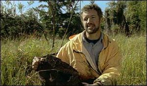
Geologist Brian Atwater shows a cross-section of cedar killed by the last Cascadia earthquake in January, 1700. Atwater discovered proof that a recurrent massive subduction zone tsunami hits the West Coast every 300-450 years (Video presentation).
According to calculations by Chris Goldfinger, a geologist at Oregon State University, there's an 80 percent chance that the portion of the fault off southern Oregon and Northern California would break in the next 50 years.
John Delaney leads the team at the University of Washington on the innovative, cabled network of instruments off the West Coast.
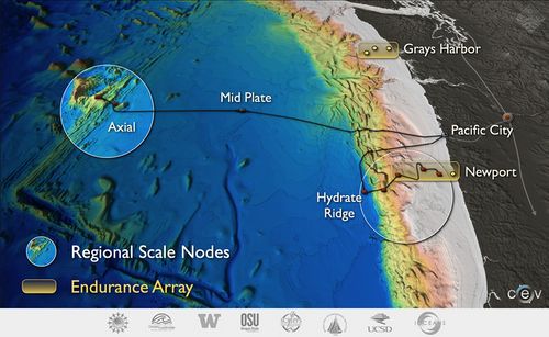
The Ocean Observatories program began in earnest in Feb, 2011, the installation of undersea power and data cables at Pacific City, Oregon, for the cabled component of the OOI.
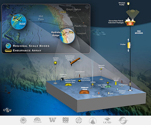
Three Implementing Organizations are responsible for construction and development of the overall program. Woods Hole Oceanographic Institution and its partners, Oregon State University and Scripps Institution of Oceanography are responsible for the coastal and global moorings and their autonomous vehicles.
Earthquakes create various types of waves with different velocities.
P-waves, for primary waves, are produced by earthquakes and recorded by seismometers. They are the highest velocity and therefore the first to be recorded. The S-wave, or secondary wave, is perpendicular to the direction of wave propagation, like waves in a rope, as opposed to P-waves like those moving through a slinky.
Each tsunameter has a pressure recorder anchored to the seafloor. The recorder’s readings were relayed to NOAA’s network of geostationary weather satellites (GOES) in the first DART models.
The real-time satellite data are analyzed at NOAA’s tsunami warning centers in Hawaii and Alaska, which issues alerts to emergency officials.
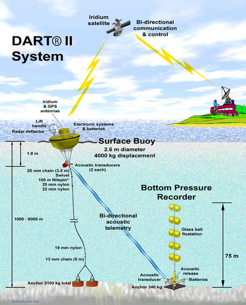
The Coast Guard uses dozens of buoys bobbing off U.S. coastlines from Maine to Alaska, which also extend the reach of a Automated Identification System. It monitors large vessels heading in and out of ports, extending the network and relaying information from hundreds of miles off shore.
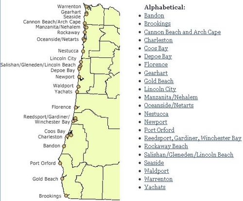
An international warning system was started in 1965, the year after tsunamis associated with a magnitude-9.2 temblor struck Alaska and the West Coast in 1964. It is administered by NOAA. The PMEL Tsunami Research Program seeks to mitigate tsunami hazards to Hawaii, California, Oregon, Washington and Alaska.
Member states include all the major Pacific rim nations in North America, Asia and South America, was well as the Pacific islands, Australia, New Zealand, France, which has sovereignty over some Pacific islands, and Russia. The Indian Ocean has rarely experienced tsunamis and does not have an active warning system.
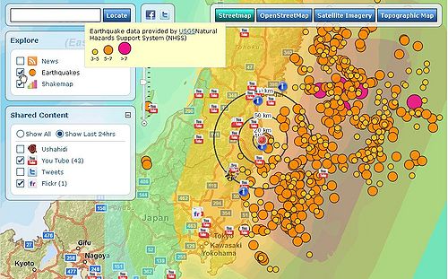
James Roddey, a geologist known as Oregon’s “Prophet of Doom,” explains it it stark terms. The coming Cascadia event could tip the scales at a magnitude above 9.5 – larger than all 20th-century earthquakes combined, according to Roddey, and last up to five minutes (Video).
Here's the scientific consensus on what will happen in Portland:
"Several of the 10 bridges across the Willamette River will collapse—the Steel Bridge, Sellwood Bridge and Marquam Bridge, most likely—and the rest will be impassible. Big Pink and other office towers will sway so violently their granite and glass façades will shear off and crash into the street, piling rubble up 4 feet deep. The Multnomah County Courthouse will tumble. Underground gas, power and water lines will be pulverized. The soil beneath the Portland International Airport will temporarily turn to soup."
The Red Cross has Earth Quake Kits and Humaninet has some tips that could save lives.
Gizmodo lists emergency apps such as Pocket First Aid and CPR, First Responder Info, Disaster Readyness, and Emergency Radio.
The 2011 Sendai earthquake and tsunami, with a magnitude of 8.9, made it the largest earthquake to hit Japan in recorded history and the sixth largest in the world since records began and may be a sister of the Earthquake and Tsunami that is likely to hit the Northwest in our lifetimes.
Ocean Observatory Initiative
The Ocean Observatories Initiative has landed this July in Pacific City, Oregon, beginning a new era in oceanography.
When the huge Ocean Observatories Project becomes operational in a couple of years, scientists will be able to listen to migrating whales, study dwindling fish stocks, spot never-before-seen microbes, watch for processes leading to major earthquakes and warn about approaching tsunami as well as pilot autonomous underwater vehicles.
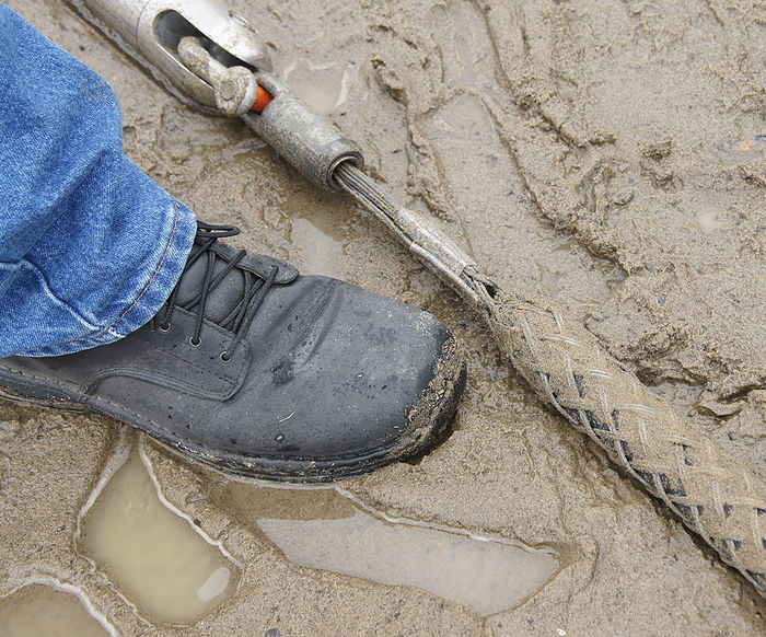
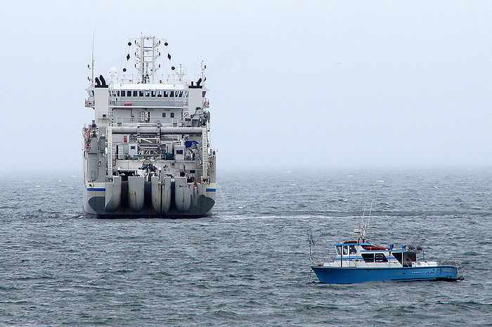
The Cable Ship Dependable laid the cable for the sub-sea science network (Facebook and Twitter). The fiber optic line also supplies electrical power to a variety of sub-sea instruments for 24/7 monitoring off the West Coast, which is due for a large subduction zone earthquake, not unlike Japan's Sendai earthquake and tsunami.
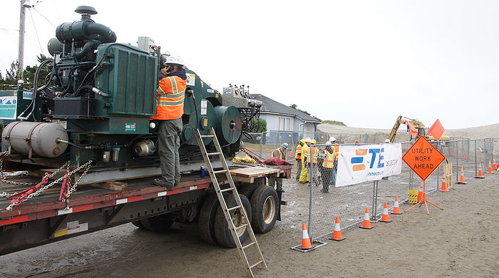
Contractor L3 MariPro and TE Subcom (formerly Tyco), brought the cable ashore. A truck-mounted wench hauled the cable through a pre-drilled conduit under the seabed, from the ship to the shore. The cable goes to a Pacific City landing station a few blocks away, then gets backhauled to Portland on an existing fiber network, then to the University of Washington, UCSD and other institutions.
Initial capacity of the RSN system will be delivery of up to 200kW of power and 240Gbps of TCP/IP Internet data communications to the seven primary science nodes.
Oceanographer John Delany
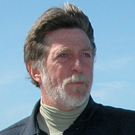
The regional cabled ocean observatory was nurtured and developed at UW, by oceanographer John Delany. John Delany has apparently managed to steer this thing though a minefield of conflicting interests, including the DOD, scientists, government bureaucrats and funding agencies.
Whether the military has negatively impacted public safety with data restrictions may never be known for sure. Delany's vision has clearly been persuasive.
Three Implementing Organizations are responsible for construction and development of the overall program. The University of Washington is responsible for cabled seafloor systems and moorings on the Juan de Fuca tectonic plate.
The University of California, San Diego is implementing the cyberinfrastructure component (pdf). NOAA standardizes different data sets into a common file format to make graphs and maps. Unidata, funded primarily by the National Science Foundation, is one of eight programs in the University Corporation for Atmospheric Research(UCAR). It provides streaming observational data to university classrooms world-wide.
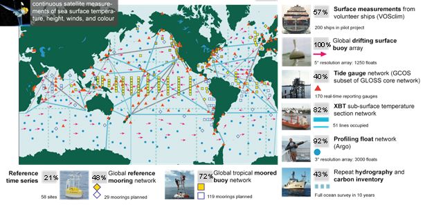
OPeNDAP and NOAA's Environmental Research Data Access Program (ERDDAP) provide software which makes local datasets accessible to remote locations. The Integrated Ocean Observing System hopes to pull it all together.
Woods Hole Oceanographic Institution and its partners, Oregon State University and Scripps Institution of Oceanography are responsible for the coastal and global moorings and their autonomous vehicles. OSU’s fleet of 21 ocean AUVs including Slocum Gliders and Remus 600 craft will be able to map ocean currents – from the surface to the bottom of the ocean – and detect where underwater "rivers" run.
Operational Ocean Observatories
There are currently more than a dozen major Ocean Observatories worldwide, with more planned.
- NEPTUNE Canada began building their network about two years ago. It's based out of the University of Victoria but remains isolated from the US regional network.
- A buoy-based observatory that [1] uses Iridium's 2.4K modem] and acoustic communication to retrieve data from water column has been deployed in 2362 m (7,750 feet) of water near Vancouver Island, BC (pdf). With the wireless acoustically linked approach, up to 15 separate instruments can be set up as far as three kilometers (1.8 miles) away from the base of the mooring.
- The Monterey Accelerated Research System (MARS) has a real-time sensor network 900 meters below the surface of Monterey Bay.
- MBARI's MARS and Neptune Canada will be integrated into a vast global network that is expected to move science in unforeseen directions.
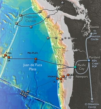
The Axial Seamount last erupted in 1998. It's 3,600 ft high, in 4,600 ft of water, just 300 mi west of Cannon Beach, Oregon. It will be wired up. Microbes scooped from hydrotermal vents and other extreme environments can create new enzymes for extreme industrial processes, like the production of biofuels from cellulose or DNA amplification (NPR: Science Friday).
Hydrate Ridge, a site for gas hydrate research, is a second area being wired with OOI sensors, starting about 50 miles offshore from Newport. The Endurance Array (graphic) includes fixed sites near Grays Harbor, WA and Newport, OR. Six autonomous gliders will bridge the distances between the fixed sites.
Jurisdictional Disputes?
Whether the Regional Scale Node will be a “dual use” observatory, supporting both science and industry, even the military, is still not clear. Their goals can be at odds.
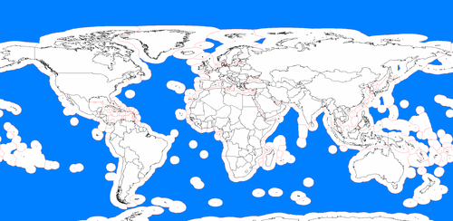
The Exclusive Economic Zone (EEZ) provides special rights over off-shore exploration and marine resources. It stretches from the coast out to 200 nautical miles.
But parts of the RSN are apparently in international waters, some 300 miles from shore. That would include the extremophile rich Axial site. The potentially fuel-rich Hydride Ridge, on the other hand, is inside the EEZ.
Neptune Canada does NOT connect to the U.S. network underwater as originally planned. Politics, not science, may have weighed against it. One might argue, for example, that OOI contractors like Raytheon, which has a good track record at software infrastructure, will come at the expense of a more open system. Raytheon's headquarters in Aurora, CO, is right across the street from NSA's Buckley Aerospace Data Facility.
The cult of Delany has helped create a base of science advocates, however, and the threat of tsunami may reinforce that support by the public. So far OOI appears to be aiming for transparency and clearly defined science goals. Climate change is a global phenomena.
You can now travel to new depths with Ocean in Google Earth.
Google collaborated with Columbia University to add their Global Multi-Resolution Topography (GMRT) so you can now explore half the ocean area that has ever been mapped, an area larger than North America.
The ultimate goal is to enable scientists to interactively visualize, analyze, and correlate petabytes of data from multiple storage sites connected to optical networks.
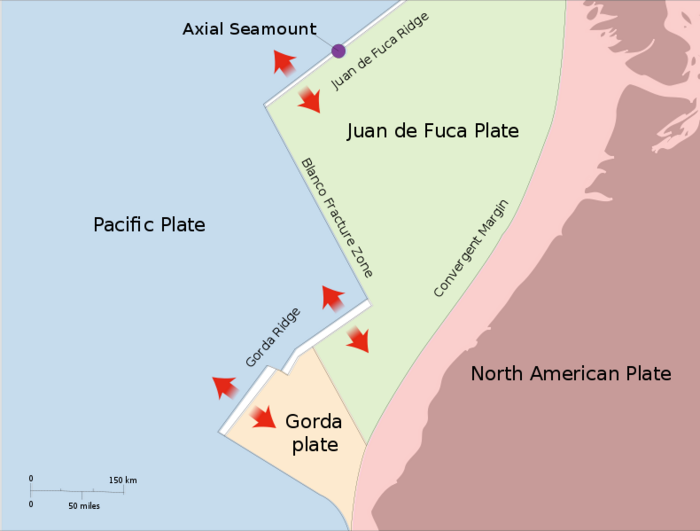
According to calculations by Chris Goldfinger, a geologist at Oregon State University, there’s an 80 percent chance that the portion of the fault off southern Oregon and Northern California would break in the next 50 years. The Cascadia Subduction Zone Quake will generate two Tsunami waves, one propagating towards the coast, and the other towards the deep ocean and Hawaii. It will take only minutes to reach the coasts of Oregon, Washington, southern British Columbia, and northern California with wave heights reaching close to 12m (~36ft) in some scenarios.
Portland's Multnomah County Courthouse will tumble. Several of the 10 bridges across the Willamette River will collapse—the Steel Bridge, Sellwood Bridge and Marquam Bridge, most likely—and the rest will be impassible. Underground gas, power and water lines will be pulverized. The soil beneath the Portland International Airport will temporarily turn to soup, says James Roddey, the Earth Sciences Information Officer for the Oregon Department of Geology.
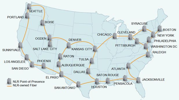
Tom DeFanti's 3D CAVE, hooked up to an Optiputer by Larry Smarr are some of the components of the new science architecture, along with shared databases for interactive collaboration.
The OptIPuter is a personal supercomputer that instantaneously connects to global databases as fast as local hard drives. The OptIPuter uses dedicated (not shared) 10-GigE optical strands. It uses a Glimmerglass optical switch to link those strands into the National LambdaRail (NLR).
In the future, oceanography, medicine, geology, physics and other science research projects will likely use high speed fiber networks and shared databases, say proponents.
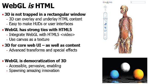
Open Geospatial Consortium encourages open standards for geospatial content and services. WebGL generates interactive 3D graphics within any compatible web browser. Google Body uses WebGL to display 3D images inside web-browsers, unlike the KML-based Google Earth application.
Sensor networks with 24/7 availability are expected to be more cost/effective and useful then sporadically sending scientists into the field to gather samples. It also allows global, real-time sharing and collaboration of data.
It's a new architecture for science.
Ari Shapiro in his Ocean Gazing Podcast, interviewed marine geologist Deborah Kelley, who expressed her goals and aspirations for OOI;
“This way, this new way of doing science, none of the data will be really protected. It’s open for the entire world to use, and I think that will be a challenge, but it’s also a gigantic opportunity. And I think that’s gonna be one of the best parts of the program.”
External Links
- Ocean Observatory Network Lands in Oregon
- The Other Atlantis
- Alaska Tsunami Ctr and Links
- Hawaii Tsunami Center and Museum
- Japan Meteorological Agency
- " target=new>Google Mapvisage
- PMEL Tsunami Research Program
- USGS Earthquake Ctr
- Oregon Tsunami Clearinghouse
- Oregon Tsunami Evacuation Zones
- Oregon Emergency Management
- Oregon ARES/RACES
- U/W’s Live Seismographs
- Cascades Volcano Observatory
- Live MT Saint Helens Seismograph
- U/W’s Recent Quakes
- Live California Seismographs
- World Quake Map
- Calif/Nev Life Seismo
- N. Calif Recorders
- US Array
- Northwest Ocean Observatory
- Savage Earth
- Discovery Planet
- Virtual Earth Quake
- International Seismological Centre
- USGS Global Quake Map
- OpenStreetMap: Sendai Quake
- Portland Open Street Map
- Tsunami Hazard Ctr
- Tsunami Mitigation
- Google Quake News
References
- ↑ Center for Coastal And Land-Margin Research - Science for Society: Impact of tsunamis on Oregon coastal communities
- ↑ Pacific Tsunami Museum